Sailor, D, Shepard M, Sheridan S, Stone B, Russel A, Kalkstein L, Vargo J, and Andersen T. “Improving Heat-Related Health Outcomes in an Urban Environment with Science-based Policy.” Sustainability 8(10), (2016): 1015. doi:10.3390/su8101015
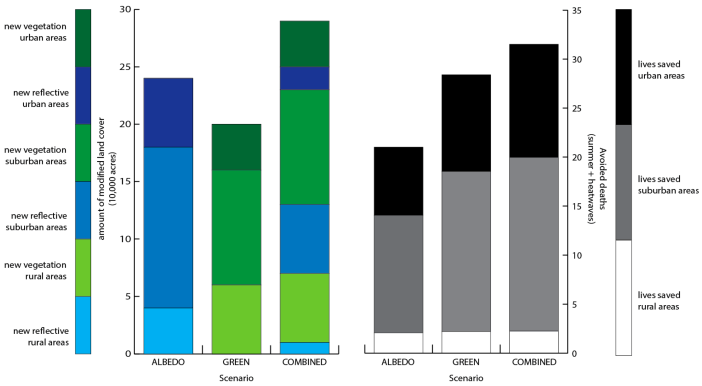 Three principal conclusions are drawn from this assessment of future land cover change and mortality in Philadelphia. First, vegetation strategies are found to be more effective overall in reducing heat-mortality than albedo strategies. This outcome occurs even though a greater total land area is converted to highly-reflective materials, suggesting that green cover yields more health protection per unit of land area conversion. A combination of vegetation and albedo-enhancement was found to be more effective in reducing future mortality than either single approach.
Second, the majority of avoided deaths under all scenarios occurs in suburban zones of the Philadelphia metropolitan region; 18 of the 32 avoided deaths under the COMBINED scenario are attributed to these zones. Given that more than half of the metropolitan population resides in suburban census tracts, heat management should not be limited to urban zones alone.
Third, heat management strategies in urban zones are disproportionately protective of health relative to suburban or rural zones. While 20% of the total land cover changes were directed to urban zones under the COMBINED scenario, 37% of the avoided deaths are located in urban census tracts. By contrast, while about 55% of the total lives saved are located in suburban zones, about 54% of the land cover changes are directed to these zones. These results suggest that each unit of heat of the land cover changes are directed to these zones. These results suggest that each unit of heat management intervention in urban zones to yield almost twice the health benefits of each unit of heat management intervention in suburban zones. Although urban heat mitigation is effective in reducing heat-related mortality throughout the Philadelphia metropolitan region, the limited climate adaptation resources should be directed to the highest density zones to maximize public health benefits.
Vargo, Jason, Brian Stone, Dana Habeeb, Peng Liu, and Armistead Russell. “The Social and Spatial Distribution of Temperature-related Health Impacts from Urban Heat Island Reduction Policies.” Environmental Science & Policy (2016) doi: 10.1016/j.envsci.2016.08.012.
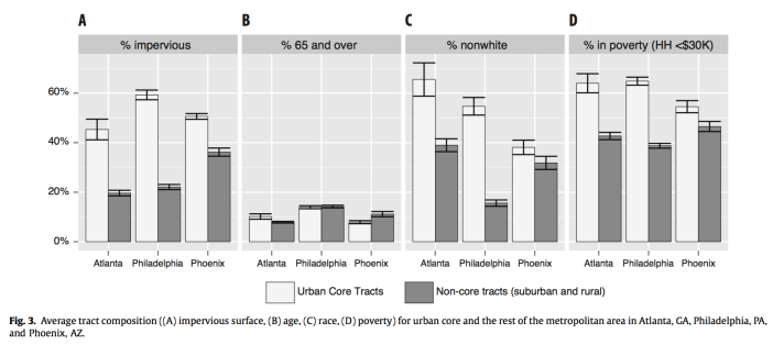
This work — available online and part of a special issue on Climate Change in the Urban Environment: Advancing, Measuring and Achieving Resiliency — analyzed earlier health modeling efforts to look at the winners in losers from blanket policies aimed at reducing the urban heat island in large US metro areas. The existing spatial distribution of residents between urban core areas and suburbs has implications for who will benefit most from such policies. For example, in Atlanta, areas of the city with large non-white populations experience greater health benefits from policies that encourage urban cooling through trees and white materials than whiter portions of the metro. The trend is opposite in Phoenix. Knowing how land use policies to reduce the urban heat island overlap with demographic factors that my impact vulnerability to heat-related health effects can help better target interventions to protect public health.
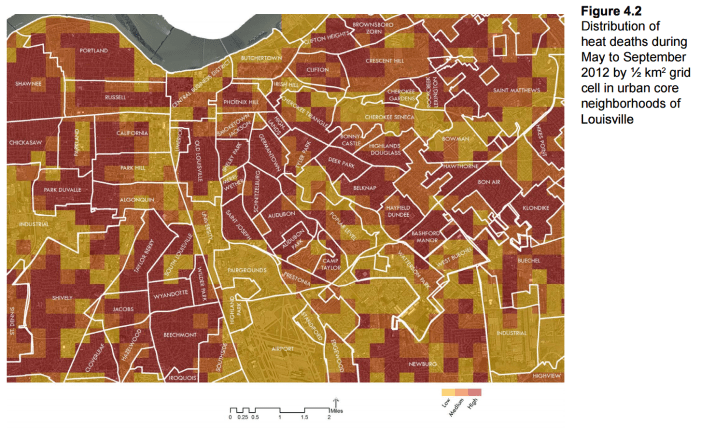
Louisville Urban Heat Management Study: A regional climate and health assessment conducted by the Urban Climate Lab of the Georgia Institute of Technology for the Louisville Metro Office of Sustainability (2016).
The study is presented in five sections, through which we first
provide an overview of the science of the urban heat island
phenomenon, its implications for human health, and how urban
temperatures can be moderated through urban design and other
regional strategies. The study next presents our methodology for
estimating the potential benefits of specific heat management
strategies for lowering temperatures across Louisville and lowering
the risk of heat of illness during periods of extreme heat. The third
and fourth sections of the report present the results of our heat
management assessment and include neighborhood-specific
findings on the potential for lessened heat risk through the adoption
of cool materials, vegetative, and energy efficiency strategies. The
final section of the report presents a set of metro-wide and
neighborhood-level recommendations for managing Louisville’s
rising heat risk, which include the following:
- Cool materials strategies should be prioritized in industrial and
commercial zones exhibiting extensive impervious cover with
limited opportunities for cost-effective vegetation enhancement. - Tree planting and other vegetative strategies should be
prioritized in residential zones, where population exposures to heat
are greatest and lower-cost planting opportunities are found. - Energy efficiency programs consistent with the Louisville Climate
Action Report and Sustain Louisville should be expanded and
integrated with urban heat management planning. - Some combination of heat management strategies should be
undertaken in every zone targeted for heat adaptation planning. - A combination of new regulatory and economic incentive
programs will be needed to bring about the land cover changes and
energy efficiency outcomes modeled through this study.
Vargo, Jason, Qingyang Xiao, and Yang Liu. “The Performance of the National Weather Service Heat Warning System Against Personal Weather Stations and Land Surface Temperature Imagery.” Advances in Meteorology(2015) doi: 10.1155/2015/649614.

This work compares heat advisories, which are issued by the National Weather Service for counties and metro areas using modeled data, to temperature records on the ground. Using weather stations as the gold standard we examined the accuracy of NWS warnings at specific locations. The work also sought to use satellite data to estimate air temperatures across the Atlanta and Chicago metro areas. Such products can improve the warning systems for local heat hazards.
Habeeb, Dana, Jason Vargo, and Brian Stone. “Rising Heat Wave Trends in Large US Cities.” Natural Hazards76:3, (2015): 1651-1665.doi: 10.1007/s11069-014-1563-z
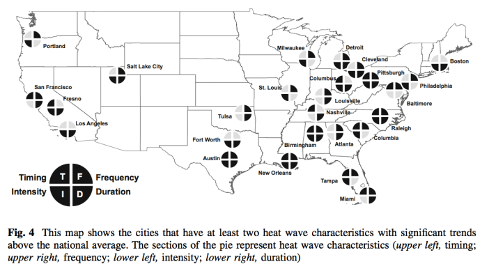
In this paper we examine 50 years of summer temperature and humidity data for medium to large US cities. We identified trends in the characteristics of dangerous heat waves that suggest increasing heat hazards for large US population centers. The frequency, intensity, duration, and early onset of such events are increasing.
Stone, Brian, Jason Vargo, Peng Liu, Dana Habeeb, Anthony DeLucia, Marcus Trail, Yongtao Hu, and Armistead Russell. “Avoided heat-related mortality through climate adaptation strategies in three US cities.” PLoS ONE 9:6, (2014): e100852. doi:10.1371/journal.pone.0100852

This work is the central paper from a three-year CDC-funded study of Climate, Urban Land use, and Excess mortality (CULE). Simulated future land covers in Atlanta, Philadelphia and Phoenix are modified under different policy scenarios to increase local vegetation and reflectivity. Corresponding future summer climate was modeled for each scenario and informed health impacts estimates from high summer temperatures and heat waves. Scenarios which modified land cover to reduce the heating effect of urbanization countered the growth in summer heat deaths from global climate change alone by 51-95%.
Stone, Brian, Jason Vargo, Peng Liu, Yongtao Hu, and Armistead Russell. “Climate change adaptation through urban heat management in Atlanta, Georgia.” Environmental Science and Technology 47:14, (2013): 7780-7786.doi: 10.1021/es304352e
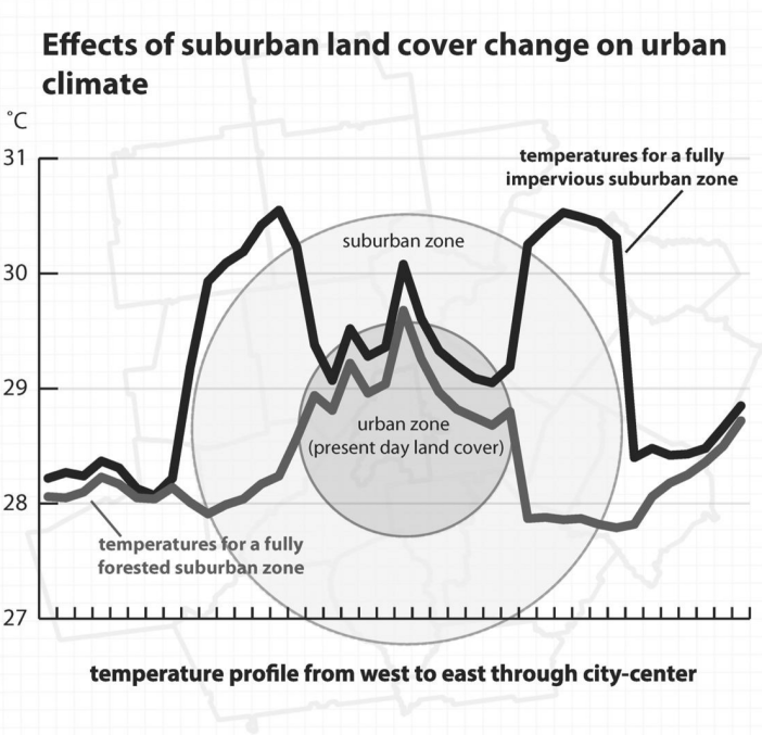
Also, a product of CULE, this work if a proof of concept for our land cover-climate modeling routine. It uses generalized land cover (existing vs. fully paved vs. fully forested) over core and exurban regions of the Atlanta Metro. The findings indicate that activities to pave over (or reforest) exurban areas – the dominant trend in Atlanta’s urban growth – have a warming (cooling) effect on proximate downtown areas.
Vargo, Jason, Dana Habeeb, and Brian Stone. “The importance of land cover change across urban-rural typologies for climate modeling.” Journal of Environmental Management 114, (2013): 243-252. doi: 10.1016/j.jenvman.2012.10.007
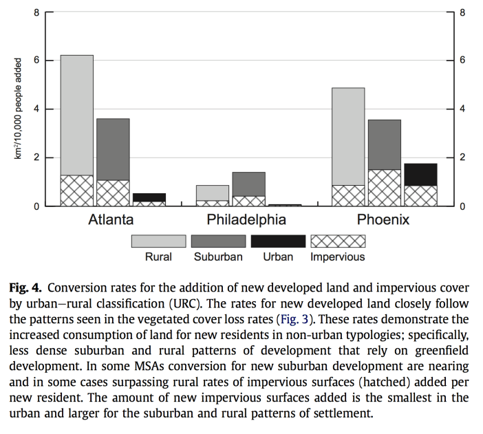
A requisite analysis for CULE, this work determined the land cover change per person for different types of urban development. The findings informed CULE’s land cover modeling and demonstrated that much of the population growth expected in many US cities is taking place through development patterns that require larger conversions to heat retaining materials. The results have implications for improving the accuracy of future land cover models in representing urban climates.
Stone, Brian, Jason Vargo, and Dana Habeeb. “Managing climate change in cities: Will climate action plans work?.” Landscape and Urban Planning 107, (2012): 263-271. doi: 10.1016/j.landurbplan.2012.05.014
Using data from more than 150 long term weather stations, this work estimates the growth in the urban heat island in US cities over the past half century. Large U.S. cities warmed at twice the rate of the planet between 1961 and 2010. By examining existing climate action plans for cities and states we found that many cities are not directly managing the urban heat island – the principal driver of urban warming.
