SOF – Bill McKibben

Yesterday I caught this show on the radio. It’s an interview with Bill McKibben. He’s an author, activist and most recently the head of 350.org. This is an agency that is “dedicated to building a movement to unite the world around solutions to the climate crisis–the solutions that science and justice demand.” The 350 refers to aiming for atmospheric carbon dioxide concentrations of 350ppm.


The radio piece is not heavily focused on faith but touches on the spirit of environmental activism as it relates to humility, and what realignments the movement and society could benefit from. I am probably messing that up so listen for yourself.

Humility

It’s a important characteristic to have and one that comes to mind when you think of our lives on the scale of earth and climate. I think it’s a good reason to advocate for changes, or rather less (climate) change. In the same vein, this frightening and prophetic advertisement from the ironically named Humble Oil company found in a 1962 issue Life magazine made me think of it.

COP15 – Google Earth Outreach Showcase

Yesterday the COP15 talks were kicked off in Copenhagen, Denmark. I took a break from writing papers to follow some links on some of the many sites devoting some time and space to this huge conference. [banner from Grist]

One of the coolest things that I found was a series of tours, demonstrated on Youtube here. It’s also a bit funny because you can hear about climate change from Ted Danson. From there you can download some of the demonstrations you watch on Youtube for real interaction within Google Earth, including full IPCC climate scenarios. It’s so cool because it easily combines modeled changes with satellite data that portrays information about land use, population and land cover. You can add and remove layers and scroll through time too (not sure how much satellite imagery will change with time). It also puts you directly in contact (with hyperlinks) with organizations and documents that back up or expand on the data. This eventually took me to their Earth Outreach page. They have a number of tools available to help non-profits visualize problems and projects using Google Earth. Below is one that I found pretty cool.


Now I’m thinking about how I can use this in my class next semester. More to follow on this and COP15.

When Pigs Flu

Anyone else on edge about this Swine Flu thing? I dare say that nowhere does such an event carry more gravitas than in the home of CDC epidemiologist in respiratory viruses. Lauren was telling me about these cases last week and when she noticed that I was only half paying attention she asked “is this sinking in?”. I guess it hadn’t until I put down what I was doing and imagined The Stand. Is anyone out there stockpiling food and water yet?

I did go back to Google Trends, the service that everyone was heralding back in November. Turns out we may still need public health surviellance. Google Trends barely showed a bleep on swine flu until this weekend. What’s more it shows nothing about the historic CDC swine flu ‘mishap’ in 1976 that pushed swine flu vaccine on the public with claims of a coming plague. The story needs to be retold today. Goolge trends did pop up with this story about the Chinese trying to get out a swine flu vaccine three and half years ago.

Regardless of investigating the history the event is a bit sureal. It’s interesting to think about the prospects of a global event that instantly puts everyone on edge, redefines stereotypes, and changes your routines (especially when you hear someone cough on the bus). I’ve provided links on the right-side banner and at the bottom of this post to info from the CDC.

CDC info on swine flu

Radiohead Videos

While putting up all these posts about the West Coast Trail trip I have had a lot of ideas for new posts. Today I saw the winners for the Radiohead Animated video contest where they asked fans to create videos for tracks on their new album. The band choose four as winners. Here’s my fave.

http://api.aniboom.com/e/235299

Here are the others:

15 Step
Entertaining Japanese-style cartoon. A boy runs and goes through psychadelic journey, the end is full of storyboards.

Videotape
This one is eerie and awesome. Mesh of real footage of lonely, beautiful and ordinary places combined with some computer animation.

Weird Fishes / Arpeggi
The beginning of this is really cool and I think the artist paid attention to what Radiohead was thinking with this song but it relies heavily on storyboards. Which, although well done, pale next to the live footage and puppets in the opening.

Until Pitchfork weighs in on them, this is the best review you have. Let me know what you think of them.

Day 7 – Crawl to the Finish

Log Jam Creek to Gordon River (5km)

Nothing was on our minds waking up this morning except finishing the hike and finishing it with everyone in one piece. We got up early, packed up camp faster than we’d ever done before and were on our way. We spoke the night before about sticking together and seeing this thing through. So it was that Rob would take the lead and set the pace.

Not too much happened on this day except that we finished. At some point in the trail you realize that everyone you pass is fresh, clean and just off the boat. Also, you can hear the ferry buzzing people to the trailhead and you begin to get excited (read impatient). At one such place in the trail we were all standing behind Rob as he calculated how to scale a fallen tree. A section of the tree had been cut out to make a step and it was about 3 feet (~1m) off the ground. He had resisted help and kept his wrists securely wrangled to his poles for 7 (or 8) days, but at this point, with a palpable urgency of 5 guys behind him, it looked as if all that would change. He began to remove his wrists from the poles’ loops and 5 men simultaneously had a common realization and a new sense of hope (like watching a Barack Obama speech). Our spirits were crushed as Rob, instead of taking Matt’s steady shoulder to aid his assent, took his poles, threw them past the opening in the tree and began to climb through on his own.

I have to admit, however, that seeing Rob finish this thing was something I thought about a lot and one of the best parts of the trip. We allowed him to lead all the way to the last kilometer, there we all took a picture with the small yellow sign that said 75km. Then, the magnetism to the finish too great to resist, we all fled for the ferry crossing, leaving Rob in our dust. He showed up a few minutes later with his poles drawn like two six-shooters. He was owed manhugs from us all and he knew they were coming.

Next began a whole other journey in itself. It was so hard to figure out who was going to Victoria General to be with Duke and who was going to head back to Seattle that I can not even remember what we did. I think Rob and Rick went to the hospital and then the four young guys also made a stop to say hi and pick up Rick. Duke was in good spirits and still telling his crushed aspirin story to anyone who would listen. We left him there with Rob while we waited, fasting and sponge-bathed, ready for surgery. He’d wait there prepped for over 24 hours more, and in the same time Rob ran around between the US Canada border like a chicken with his head cut off trying to get his other car up to Victoria (still, no one understands why). We arrived in Seattle and dropped off Rick, sometime around midnight (Thursday night/Friday morning), but determined to get some beer before passing out. Duke would finally make it back to Seattle on Saturday and we went over to visit on Sunday. He was bumped in the queue for surgery 5 times and finally gave up, came back to Seattle and had an appointment with his doctor for Tuesday. He had talked to George who had somehow made his way back to New Mexico since we last saw him.

Skip to the present. This weekend Matt is again out in Seattle with Duke, Rob, Graham and Josh for Graham and Liz’s wedding. Best wishes to all of you guys and I hope to get back out there soon. It was the trip of a lifetime… until the next trip.

http://picasaweb.google.com/s/c/bin/slideshow.swf

Day 6 – Just a Perfect Day

Camper Bay to Logjam Creek (8km)

We woke up happy to notice the morning absent the sound of water hitting our heads. It was not raining, we’d been able to dry some things out the night before and we even got a fire going in the morning to try and dry some more. The discussion about whether to push to the finish or go our own pace continued but now without words. We weren’t going to get the early start that might have allowed us to finish by going our own pace and, in fact, there would still shelter to break down at 8:30. This is what Josh called the work of a subtle saboteur. Regardless, we started the day with a cable car and then headed into the forest for more of the rugged, boggy terrain that we had seen the day before.

I think we were all happy to see that it was noticeably more dry and easier than yesterday. Nonetheless, the up and down over uneven roots and fallen trees made you pay attention to every step. Rob was reliant on his poles and defiant to accept any help with the tougher to negotiate spots. He had taken a few spills on Day 5 but kept pushing along. Day 6 would be more of the same for him. After a few km he, Matt and Duke were hiking at the back of the group. The rest of us stopped at a beach access trail to wait for them but were surprised at how long it was taking. It turned out that Rob had taken a fall that put him in touch with a stump and he now had a gash (about 1″ long; 2.54cm) squarely in the middle of his forehead. Matt had a ziplock full of bloody gauze and tissues to prove it. Minor crisis handled.

We skipped the beach access and pushed on. About 300 meters (or maybe 150 yards) down the path we came to the bridge over 150 yard Creek. Matt and I crossed, commenting on the missing boards and single-sided handrail, and were on the other side when we turned around to See Duke face down on the side of the ravine. Rick worked his pack off, we sat him up on the bridge and eventually we tried to see if he could put some weight on his legs. We knew that he had injured himself and thought it could have been serious (after sitting up he briefly blacked out, likely due to the pain). Standing up was not successful and we prepared to sit him down and call for help.

Our cells phones didn’t work and the VHF radio we had could only receive, not send. Mostly we could either get the weather report or listen to fisherman and leisure boaters talk about old Norwegian-made skiffs. Finally a group of Canadians passed with a cell phone that they graciously let us borrow and we reached the rescue service and made them aware of our situation and position. A helicopter would be deployed.

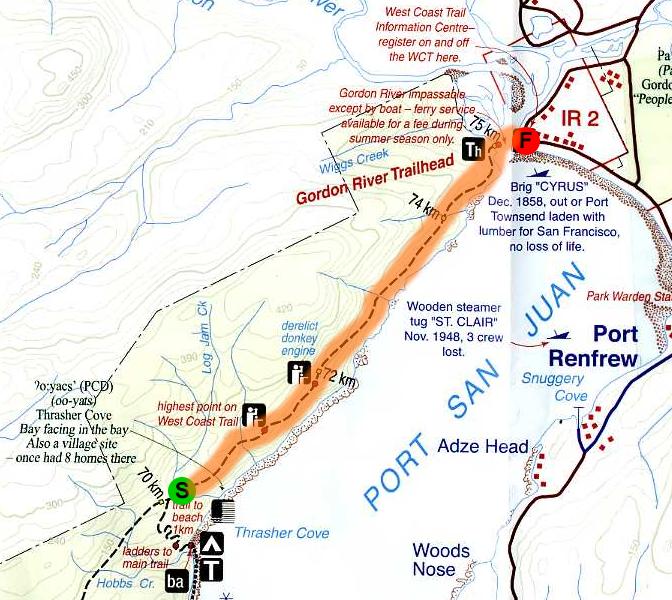
We set up a mini-camp to get Duke’s leg stabilized and on a thermarest and his body warm and fed. We made some hot water and waited for the rescue team to radio us. I have no recollection of time during this. Finally they called to say the helicopter was leaving and heading to beach access B (see map) about 300 meters, or 8 min of normal hiking, back on the trail. We heard the copter within 3 minutes and Matt and I rushed to meet it.

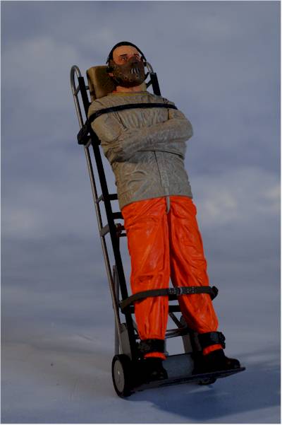
Two rescue workers exited the plane and recognized our excitement at the novelty of this unfortunate event and they put us to work. Matt carried the stretcher into the site and I helped out with rope bags. Shannon (the female rescue worker with whom Duke had spoken two days prior at a lighthouse encounter) got his leg into a vacuum jacket. James (the other rescuer) set up some ropes near the beach. Like most of the beach access points this one had the trail meeting the beach at a cliff of sorts and this one was luckily short at about 30 feet down a ladder. Since you can’t go down a ladder on a stretcher, James would anchor a rope rig around some trees and we would lower the stretcher over the side of the cliff with a couple of us on the ladder guiding the things down with a free hand.

Once we finally got Duke on the stretcher it took all four of the youngsters along with Shannon and James to navigate and maneuver the thing down to beach access B. I would say this took over an hour. Two locations were ravine crossings formed with fallen trees. We tied a rope to the front of the stretcher and a couple of us would pull Duke along the top of the log while the others would position ourselves next to the log, sometimes into the ditch, and guide him across. Once we reached the cliff there was one more small detail to work out: Duke had to stabilized so that as the stretcher became vertical and went down the cliff he would not put weight on the bad leg. Shannon tied some fancy knots and we figured we had it. To test it we tilted the stretcher up and let Duke relieve himself, his body completely strapped to the stretcher. It was like silence of the lambs, minus the muzzle. At about this time the pilot came up to say that the tide was coming in and that he was going to have to move. James pushed for a few more minutes and we successfully got Duke to the helicopter with minutes to spare.

By now Matt, Graham and I had sent Rick and Rob with Josh to start moving toward the next campsite. It was getting late and we had about 4km to go before we could stop. We decided to try for a small campsite off the trail just south of the path to the Trasher Cove Beach campsite. We knew we couldn’t make it to the Cove (1 km for the actual trail) and we didn’t want to add that 1 km onto the next day either so we were shooting for Log Jam Creek. When we caught up to the crew in front we still had over a km to go and it was nearing 8PM if I recall correctly. We also found out that more blood had been shed, as Rick ran his head into a low clearance fallen log. Scalp wounds are known to produce a deceiving amount of blood (I should know), but Dr. Rob patched it up with superglue. We finally pulled into to our site sometime after 9 and quickly set everything up, got water, made dinner and hung the food. Our three tents barely fit in the space. If someone else had already set up shop there we would have been out of luck. We were so close that there was really very little on everyone’s minds except for where Duke was and finishing the trail. We had just finished a day where four of us managed not to get hurt.

http://picasaweb.google.com/s/c/bin/slideshow.swf

Day 5 – Rain Forest

Walbran Creek to Camper Creek (9km)

I better get this story down before I forget the dirty details. On day 4 I noted the sound of the rain on the tent as we fell asleep. Well, it was still raining in the morning and on Day 5 we had finally arrived in the Pacific Northwest. The rain had moved in and sat on us for the entire day. We set up camp in an efficient manner and started toward our next destination: our full day of travel in the forest (no beach).

Before anyone can go on the West Coast Trail they have to go through an orientation. In it they tell you about the animals, the campsite amenities, the ladders, the cable cars, and they walk you through the whole trail. Here they tell you about which sites might be closed, and where water can be found. We did the orientation at Port Renfrew so they walked us through the route from south to north. They always mention that the south portion is the easy part and if you are heading north once you hit Walbran you’ve finished the first (difficult) section and you have only 53 km left (easy). You’ll notice that on Day 5 we started at Walbran Creek (kilometer 53).

We trudged through Day 5. I remember being in good spirits despite being soaked. I also recall huge sections of ladders and a long bridge at Logan Creek. With about one or two kilometers left, Josh and I went ahead to find a spot at Camper Bay and hopefully to get a fire started. We arrived to find one of the smallest sites we’d seen on the trip and certainly the one with the smallest amount of firewood and none of it dry. Surprisingly, the site does have two food lockers and two toilets.

Despite the lack of dry wood we were lucky to be the second group to arrive that day and we began to salvage any wood that looked like it might burn and try to get a fire underway. Some native Vancouver Island guys made up the group that beat us to the site and had already claimed the good wood. They also had a tarp up and had a fire going. The rest of our group arrived shortly and soon we were all freezing. Priorities included getting the tent up and changing clothes. About an hour after I arrived we still had very little flame going and I got in my sleeping bag and took a nap. Feeling lazy and hearing everyone else still outside and moving around I got up a bit later and found that our fire was under way. Rob, who was without a change of clothes and flush with solid fuel for a stove we would never use, had been working on it and finally got it going. We could not have done it without him and an awkward German/Japanese guy who came over to our camp and sawed some wood. Thanks guys.

Eventually the rain subsided after what I estimate to be about 21-22 hours. We somehow had the most kickass fire in the whole bay. By now travelers were rolling in along with stories about the route ahead and how tough it would be from here to the finish. Some arrived after nine hours of wet hiking all the way from Port Refrew but all of them looked at our fire with envy as we dried our clothes. Some people even came over to use it on their own clothes. In the morning it was more of the same, we got the firs going and dried some more before setting off. It wasn’t the sunny weather we had enjoyed earlier in the trip but we had weathered the worst of the storm. After such a trying day there was some argument about how far to go on the next day. Some thought we could push all the way to the finish, but we would have to get an early start and reach the Gordon river crossing before 4:00 to catch the ferry. Others resisted the pressure and insisted we not push it and see where we are as the day progressed. Neither of those happened.

http://picasaweb.google.com/s/c/bin/slideshow.swf

Day 4 – Monkey Farts

Cribbs Creek to Walbran Creek (12km)

Coming off the high of Day 3, and anticipating more great weather we once again opted for an early start. This would get us moving and set up at the next campsite with time to relax and enjoy the evening. Getting to site’s early also ensured that we would get space in the food locker, firewood – though this was hardly ever in short supply – and a good campsite.

Once packed up at Cribbs our day went pretty much as expected. The early morning mist burned off just as we came to Chez Monique’s. This is the very famous ‘restaurant’ set on First Nation land along the trail. Crab omelets and burgers were available for $20 as well as soda, beer and an assortment of candy. They even had bottles of wine for purchase. The whole situation is a little weird with huge piles of trash behind and next to the kitchen area. For the first time in days we saw pieces of the civilization they had tried to escape briefly and it was a bit ugly, albeit delicious. At the same time I think I romanticize it all more than others. Sitting around the table the group engaged in some vigorous debate and complaining about kids these days. A woman, perhaps Monique herself, chimed in and imparted a bit of wisdom about how giving makes one rich, and ironically Rich was the least willing to accept this.

The day went on in sunny, gorgeous fashion that was all beginning to seem pedestrian (pun intended) to us. When we arrived at at Walbran I laid down next to the fire ring and took a nap in a bbq pit, as Matt so appropriately described it. Our final custom-made-Duke-dinner was prepared: re-fried beans and rice with cheese in soft wheat tortillas. There was also more bacon from the huge Costco bag, which miraculously was finished on its second day. Duke suggested that we also go ahead and make the field tiramisu that we had prepared for Matt’s birthday (still 2 days away). We all agreed that it was a good night for it and it would make the packs lighter. This line of reasoning is what also led to the early devouring of the biscotti (2/person) on the previous night. Field recipe tiramisu probably sounds risky to impossible but it was awesome. Well done Duke and Graham on all the prepared meals!

The rest of the night was spent creekside skipping rocks, chatting and throwing monkey farts – a trick Matt showed us. You take a rock that might be good for skipping and throw it high up into the air. You want it to hit the water exactly opposite of what you are going for with skipping. The sound you hear is supposed to resemble that of a monkey farting. The rocks here and the still, deep river are perfect for it.

Walbran Creek is the first site where we heard about the mice. Some of the sites are very close to the woods and at night they come out and they will get into things. Matt and I had selected a spot right at the edge of the woods and we heard tons of them scurrying around and squeaking to each other. At one point a mouse came under the fly and onto the tent. To be exact it was on the outside of the tent right over Matt’s head, which because of the design of the tent and the height of Matt meant that Matt could feel it on his head. We are wimps. I’m not sure how we
fell asleep but I remember it starting to rain before I drifted off.

http://picasaweb.google.com/s/c/bin/slideshow.swf

Day 3 – Swimming

Tsusiat Falls to Cribbs Creek (16km)

I woke up this morning nervous about the back of my foot. I had a sharp pain from the way the back of the boot folded and put pressure on my Achilles when I took a step. Also, I had just finished a day that I thought was the worst of the trip so far but I was not about to quit or complain. Of course neither would have done me any good. Richie “Hollow Point” Powell hooked me up with some anti-inflammatory meds and I laced my boots up in their old ‘classic’ way (the same as from the first two days, but I had strayed from this style the on the day before). I felt pretty good as we set off from the falls.

This day’s hike was scheduled to be a long one, since there were limited points at which to obtain water and a camp site in the middle – Cheewhat River – was closed due to bears in the area. It would be our longest of the trip at over 16km. Thus we got an early start and the organic rhythm that began to make itself apparent the night before again appeared, this time a bit more refined still. The early start did us well. We started on the beach and came up to Hole in the Wall within the first hour, a classic spot on the trail.

In addition to the early start the group had vowed to avoid the mistake of the prior day which was to skip lunch so as to reach our final goal even faster. This last goal wasn’t much of a problem because of the ferry crossing at Nitinat Narrows. When we arrived the sun was shining and the sky was blue. On the other side of the crossing there were fresh crab lunches ($20) and beers ($5) to be had by the rich.
Following lunch we continues on in the good weather and after km36 we popped out on a beautiful beach and took some time to admire it. The weather seemed to carry us and the weight of the packs was no longer obvious but more assumed and beginning to feel natural. I think it surprised everyone when we arrived to our destination; I thought we had about 3km to go.

On the far side of Cribbs Creek we found a nice shelter next to a small stream and a wall of rocks. We all went for a dip in the ocean, tried to dry some clothes in the sun, and made the most of this late afternoon glory. Josh and I tried to do some climbing on the rock wall next to the site. For dinner we had what was called the unwrapped baked potato. It was dehydrated mashed potatoes, vegetable medley, pepperoni, cheese, bits of real bacon and butter buds. That’s right we carried with us pepperoni, smokes salmon, and real bacon (a huge Costco bag that was subsequently used for snacking, throwing a pinch in like a chew and with meals that followed) through bear country. It was a bit salty but hardy. We sat on the rocks and watched the sun set. Having accomplished our loftiest goal thusfar and with our spirits lifted by the beauty of the place we were part of, we felt optimistic about the rest of the journey.

http://picasaweb.google.com/s/c/bin/slideshow.swf